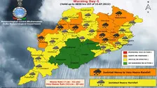

A low pressure system is likely form over Northwest & adjoining Westcentral Bay of Bengal around August 7, the India Meteorological Department (IMD) said on Thursday.

The southwest monsoon is now going through a weak phase in Odisha. The dry spell has led to apprehensions in some parts of the state which have received deficient rainfall in the Shravan month so far.

The Twin Cities of Cuttack and Bhubaneswar experienced intense spells of rain since early morning under influence of a low-pressure area over coastal Odisha on Saturday.

The well-marked low-pressure area over south coastal Odisha and neighbourhood is now seen as a low-pressure area over north Odisha and neighbourhood.

The weather office has issued yellow as well as orange warning for several districts for the next five days.

As per IMD, the system is very likely to become more marked during the next 48 hours.

As per IMD’s Regional Centre in Bhubaneswar, the rainfall activities are likely to continue for the next 4-5 days in the State.

In view of the forecast, the Special Relief Commissioner (SRC) on Sunday issued advisory to Collectors of all districts.

Cyclone Asani: Scenes From Andhra Pradesh

Asani Wind Impact: Gold Painted Chariot Washes Ashore Srikakulam in Andhra Pradesh

Cyclone Asani: Heavy Rainfall, Strong Winds Batter Andhra Pradesh

As per IMD, It is very likely to move north-westwards and intensify gradually into a depression during the subsequent 48 hours.

IMD Director General, Mrutyunjay Mohapatra, said the system will develop into a low pressure area around May 6. There is possibility that it will move in north-west direction for the next two days and may intensify into depression.

As per IMD, a cyclonic circulation is likely to form over south Andaman sea and neighbourhood around May 4. under its influence, a low pressure area is likely to form over the same region around May 6.

As per India Meteorological Department (IMD), a cyclonic circulation is likely to form over South Andaman Sea and neighbourhood around May 4. Under its influence, a low pressure area is likely to form over the same region around May 6.

Copyright © 2024 - Odisha Television Limited All Rights Reserved.