
As the system is situated far away from Odisha, its impact will not be seen now. However, the current weather conditions in the form of rainfall activities in Odisha are under the influence of Nor’wester, said IMD DG Mrutyunjay Mohapatra.

IMD Director General, Mrutyunjay Mohapatra, said the system will develop into a low pressure area around May 6. There is possibility that it will move in north-west direction for the next two days and may intensify into depression.

Senior scientist of the India Meteorological Department (IMD) RK Jenamani has shared latest updates on probable cyclone ‘Asani’ and its impact on east coastal belt and Andaman Nicobar islands.

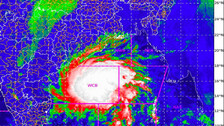
The Deep Depression or the remnant of cyclonic storm ‘Jawad’ weakened into a depression over northwest Bay of Bengal close to southeast of Puri at 2.30PM on Sunday (December 5).

The city of Bhubaneswar witnessed cloudy sky with a few intense spells of rain and strong gusty surface winds over some areas. Owing to the Jawad-induced rains, people in several low-lying areas were left to grapple with water-logging situation. Even though the system has already weakened into a depression, rainfall activity is likely to continue in the smart city, predicts MeT.

The Deep Depression lay centered at over northwest and adjoining westcentral Bay of Bengal about 90km south- southeast of Gopalpur and 120km south-southwest of Puri.

The Deep Depression remnant of cyclonic storm `Jawad' over west-central Bay of Bengal is likely to move north-northeast wards, weaken further into a Depression and reach Odisha coast near Puri around Sunday noon.

Bhubaneswar IMD Director HR Biswas has shared the latest updates on cyclonic Storm ‘Jawad’. As per the forecast, the cyclonic storm is moving in north-northeast direction and will continue to move in that direction.

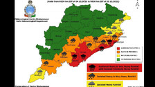
As per IMD, several parts of Odisha will experience moderate to heavy rainfall from December 3 and the intensity of rain will increase from tomorrow (December 4).

The Cyclonic storm will re-curve and move towards West Bengal, said India Meteorological Department (IMD) DG, Mrutyunjay Mohapatra on Friday.

As per the India Meteorological Department (IMD) forecast, the cyclonic storm is likely to re-curve (while in sea) and, as per the path, may brush Odisha’s coast near Puri.

The Depression over south-east Bay of Bengal has intensified into a deep depression. It is very likely to intensify into a cyclonic storm during the next 12 hours and reach north Andhra Pradesh and Odisha coasts by tomorrow morning.

Red warning for heavy to very heavy rainfall with extremely heavy falls (more than 20 cm) has been issued for Gajapati, Ganjam, Puri, and Jagatsinghpur on December 4.

Yesterday’s low pressure over south Thailand and neighbourhood has emerged into Central Bay of Bengal. It is likely to move west-northwestwards and concentrate into a Depression over southeast and adjoining east-Central Bay of Bengal by tomorrow (December 2).

The Depression is likely to intensify into a Cyclonic storm around December 3 and it will move northwestwards and reach north Andhra Pradesh-Odisha coast around December 4 morning.

Copyright © 2024 - Odisha Television Limited All Rights Reserved.