Twitter
 Telegram
 Google News
Thunderstorm Alert
The India Meteorological Department (IMD) on Tuesday predicted thunderstorm activities in several parts of Odisha over next 48 hours.
As per IMD’s Regional Centre in Bhubaneswar, thunderstorm with lightning is likely to occur in several parts of the State starting from today. A ‘Yellow Warning’ has also been issued in this regard.
The weather agency further said that there will be no large change in the maximum temperature (day temperature) at many places in Odisha during the next 4-5 days.
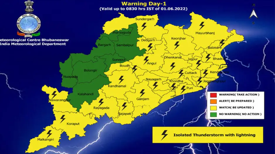
Weather Forecast: Day-1 (valid up to 0830 hrs IST of 01.06.2022)
Yellow warning (be updated): Thunderstorm with lightning is very likely to occur at one or two places over the districts of Balasore, Bhadrak, Jajpur, Kendrapara, Cuttack, Jagatsinghpur, Puri, Khordha, Nayagarh, Ganjam, Gajapati,Sundargarh, Deogarh, Keonjhar, Mayurbhanj, Angul, Dhenkanal, Kandhamal, Boudh, Rayagada, Koraput, Malkangiri and Nabarangpur.
Day-2 (valid from 0830 hrs IST of 01.06.2022 up to 0830 hrs IST of 02.06.2022)
Yellow warning (be updated): Thunderstorm with lightning is very likely to occur at one or two places over the districts of Malkangiri, Koraput, Rayagada, Nawarangpur, Gajapati, Ganjam, Mayurbhanj, Keonjhar, Balasore, Bhadrak and Jajpur.
Day-3 (valid from 0830 hrs IST of 02.06.2022 up to 0830 hrs IST of 03.06.2022)
Light to moderate rain or thunderstorm is very likely to occur at one or two places over the districts of Malkangiri, Koraput, Nabarangpur,Rayagada, Gajapati, Keonjhar, Mayurbhanj, Balasore, Bhadrak and Kalahandi.
Day-4 (valid from 0830 hrs IST of 03.06.2022 up to 0830 hrs IST of 04.06.2022)
Light to moderate rain or thunderstorm is very likely to occur at one or two places over the districts of North Coastal Odisha, Malkangiri, Koraput, Rayagada, Gajapati, Ganjam, Keonjhar, Mayurbhanj.