Twitter
 Telegram
 Google News
Low Pressure Likely To Form Over BoB Around July 11; Check Latest Weather Updates For Odisha
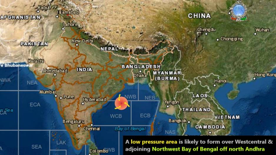
A Low Pressure area is likely to form over West-Central and adjoining North-West Bay of Bengal off north Andhra Pradesh-South Odisha coasts around July 11, informed the India Meteorological Department (IMD) on Tuesday.
A north-south trough runs from north Bihar to north Coastal Andhra Pradesh across Jharkhand and interior Odisha and extends upto 2.1 km above mean sea level, the IMD said.
The cyclonic circulation over north Odisha and adjoining Gangetic West Bengal extending upto 1.5 km above mean sea level has become less marked and the trough from this cyclonic circulation to north Coastal Andhra Pradesh has also become less marked.
Weather forecast and warning for districts of Odisha for next five days:
Day 1 (valid from 1330 hrs IST of 06.07.2021 up to 0830 hrs IST of 07.07.2021)
Yellow Warning (To be updated): Thunderstorm with lightning is very likely to occur at one or two places over the districts of Balasore,Bhadrak, Jajpur, Kendrapara, Cuttack, Jagatsinghpur, Puri, Khurda, Nayagarh, Ganjam,Gajapati, Keonjhar, Mayurbhanj, Angul, Dhenkanal, Boudh, Kandhamal, Rayagada, Koraput and Malkangiri.
Day 2 (valid from 0830 hrs IST of 07.07.2021up to 0830 hrs IST of 08.07.2021)
Yellow Warning (To be updated): Heavy rainfall is very likely to occur at one or two places over the districts of Balasore, Bhadrak,Jajpur, Kendrapara, Cuttack, Jagatsinghpur, Keonjhar, Mayurbhanj, Dhenkanal. Thunderstorm with lightning alert has been issued for Balasore, Bhadrak, Jajpur, Kendrapara, Cuttack, Jagatsinghpur, Sundargarh, Jharsuguda, Bargarh, Sambalpur, Deogarh, Angul, Dhenkanal, Keonjhar, Mayurbhanj, Khurda, Puri, Koraput, Malkangiri, Nabarangpur.
Day 3 (valid from 0830 hrs IST of 08.07.2021up to 0830 hrs IST of 09.07.2021)
Yellow Warning (To be updated): Heavy rainfall is very likely to occur at one or two places over the districts of Angul, Dhenkanal, Keonjhar, Mayurbhanj, Deogarh, Boudh, Sonepur, Bolangir, Cuttack.
Thunderstorm with lightning is very likely to occur at one or two places over the districts of Balasore, Bhadrak, Jajpur, Kendrapara, Cuttack, Jagatsinghpur, Sundargarh, Jharsuguda, Bargarh, Sambalpur, Deogarh, Angul, Dhenkanal, Keonjhar, Mayurbhanj,Khurda, Puri, Nayagarh, Kandhamal, Boudh, Kalahandi, Bolangir, Nuapada.
Day 4 (valid from 0830 hrs IST of 09.07.2021up to 0830 hrs IST of 10.07.2021)
Yellow Warning (To be updated): Heavy rainfall is very likely to occur at one or two places over the districts of Kalahandi, Nuapada, Bargarh, Bolangir, Sambalpur, Deogarh, Jharsuguda, Sundargarh, Nawarangpur. Thunderstorm with lightning is very likely to occur at one or two places over the districts of Sundargarh, Jharsuguda, Bargarh, Sambalpur, Deogarh, Angul, Dhenkanal, Keonjhar, Mayurbhanj,Sonepur, Boudh, Nuapada, Balangir, Kalahandi, Kandhamal, Nawarangpur, Rayagada, Koraput, Malkangiri, Nayagarh, Ganjam, Puri, Khurda, Cuttack.
Day 5 (valid from 0830 hrs IST of 10.07.2021up to 0830 hrs IST of 11.07.2021)
Yellow Warning (To be updated): Heavy rainfall is very likely to occur at one or two places over the districts of Koraput, Malkangiri,Nabarangpur, Nuapada, Rayagada.
Thunderstorm with lightning is very likely to occur at one or two places over the districts of Puri, Khordha, Nayagarh, Ganjam, Gajapati,Sonepur, Boudh, Nuapada, Balangir, Kalahandi,Kandhamal, Nabarangpur, Rayagada, Koraput, Malkangiri, Bargarh, Jharsuguda, Sundargarh.