
Not only paddy, but vegetable and other small marginal farmers who had cultivated other crops are also a worried lot about the impending storm.

IMD has also predicted Gale wind and light to moderate rains along the Odisha and Andhra Pradesh coast from May 10 to 12.

Sea conditions that are very rough on Monday evening are likely to turn high over north Andaman Sea and adjoining southeast and east-central Bay of Bengal and on Tuesday, very likely to become very rough to high over east-central Bay of Bengal and north Andaman Sea and along and off Myanmar coast.

Light to moderate rainfall, thundershower at most places with heavy to very heavy rainfall at isolated places is very likely over Nicobar Islands on Friday as a Low Pressure Area (LPA) in south-east Bay of Bengal is likely to intensify into a cyclonic storm by March 21.

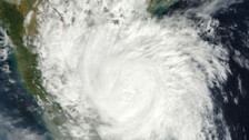
Tourists asked to vacate Puri Beach in view of cyclone Jawad. As per IMD, Jawad is expected to weaken into deep depression as it reaches Puri.

In a little good news as termed by the Odisha Special Relief Commissioner, the cyclonic storm Jawad is likely to weaken gradually in the next 12 hours.

Cyclonic Storm JAWAD is likely to weaken gradually in next 12 hours & reach Puri around Dec 5th noon as a Deep Depression

The Depression over south-east Bay of Bengal has intensified into a deep depression. It is very likely to intensify into a cyclonic storm during the next 12 hours and reach north Andhra Pradesh and Odisha coasts by tomorrow morning.

As per the latest forecast by the Bhubaneswar Centre of the India Meteorological Department (IMD), the low pressure area over South Thailand and neighbourhood with the associated cyclonic circulation is likely to intensify and reach North Andhra Pradesh-Odisha coasts by the morning of 4th December, 2021.

As per the latest forecast by the India Meteorological Department (IMD), a low pressure area lies over South Thailand and neighbourhood and is likely to emerge into Andaman Sea during the next 12 hours.

Odisha has sounded alert after the India Meteorological Department (IMD) forecast a low pressure area over South Andaman Sea on November 30. The Low Pressure is expected to develop into a cyclonic storm in the first week of December.

Earlier on Monday, Koraput, Gajapati and several other southern districts of Odisha recorded very to very heavy rainfall under the influence of the cyclonic storm. In the last 24 hours, Pottangi in Koraput has experienced highest rainfall - 148.0mm followed by Mahendragarh with 89.4mm.

Severe cases of El Nino, as in 1997/98, are responsible for drought, flooding, as well as areas of formation for tropical cyclones and severe winter storms.

Bhubaneswar: The India Meteorological Department has issued a cyclonic storm warning in the next 24 hours due to a deep depression over Bay of Bengal. A cautionary signal-1 warning has been issued for all the ports along the Odisha coast. As per the latest release of the Met department, the cyclonic storm is very likely […]

Bhubaneswar: The cyclonic storm Phethai, which is likely to cross Andhra Pradesh coast between Machlipatnam and Kakinada today, triggered rainfall in several parts of the State. The cyclonic storm is situated 270 km South-West of Kakinada and is expected make landfall today afternoon, informed an official of Regional Meteorological Centre, Bhubaneswar. “The wind speed is […]

Copyright © 2024 - Odisha Television Limited All Rights Reserved.