Cyclone Asani: Heavy Rainfall, Strong Winds Batter Andhra Pradesh
The deep depression, which is currently lying at 1100 km south-southeast of Puri over the Bay of Bengal, has turned into a cyclonic storm today, informed India Meteorological Department (IMD) on Sunday.
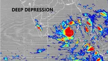
The Depression over Southeast Bay of Bengal has intensified into a Deep Depression, the India Meteorological Department said in a bulletin on Saturday.
The IMD bulletin said while many places witnessed light to moderate rainfall, isolated heavy rainfall occurred over Nicobar Islands during the last 24 hours; light to moderate rainfall also occurred at a few places over Andaman Islands during the same period.
Meteorologists said that the movement of system over the Bay of Bengal may take the temperature soaring in Tamil Nadu. The IMD also predicted that without strong winds flowing from any direction, the temperature during the day will increase.
Here are some of the crucial measures that the people living in cyclone affected areas need to keep in mind in view of the strong wind and heavy rainfall triggered by cyclone Jawad.
“Odisha has been receiving light to moderate rainfall since yesterday evening while Ganjam, Puri, Jagatsinghpur and Khordha districts are likely to witness heavy rainfall. Cuttack and Bhubaneswar are likely to receive maximum rainfall of 200 mm today,” informed Jena.
According to the latest reports, cyclone Jawad will make landfall in an area south of Puri in about 36 hours from now.
47 teams of the Fire Services have been kept on standby mode at Naraj in Cuttack, the quick action team has been mobilised and kept on standby to combat any situation.
Similarly, the Koraput district administration has also cancelled the leaves of all the government officials in the district with immediate effect till December 5.
Winds at around 90 to 100 kmph are likely to lash the coast under the influence of the probable cyclonic storm heading towards Odisha and Andhra Pradesh coasts. The cyclonic storm is expected to reach Odisha and Andhra Pradesh Coasts on December 4th. This information was shared by India Meteorological Department DG, Mrutyunjay Mohapatra on Thursday.
The Odisha government will start sending response teams like NDRF, ODRAF and Fire service personnel to different districts from tomorrow, the Special Relief Commissioner said on Wednesday.
The low-pressure system formed over the Central Andaman Sea has been active and will intensify into Depression by tomorrow while moving in the West-Southwest direction, informed the Bhubaneswar Centre of the India Meteorological Department (IMD).
In the latest advisory issued in the backdrop of IMD’s forecast for heavy rainfall, the SRC office has asked the district Collectors to monitor the situation closely.
IMD DG Mrutyunjay Mohapatra shares details on probable cyclone over Bay of Bengal
Ahead of formation of a low pressure area (LOPAR) over North Andaman Sea around October 10, the regional centre of the India Meteorological Department (IMD) has issued a 'Yellow Warning' for thunderstorms and lightning over several districts of Odisha.
The Bhubaneswar Centre of the India Meteorological Department (IMD) informed that a low pressure area is very likely to form over north Andaman Sea around 10th October.
The India Meteorological Department IMD) has issued a forecast suggesting that the low pressure is likely to form over North Andaman Sea around October 10.
Earlier on Monday, Koraput, Gajapati and several other southern districts of Odisha recorded very to very heavy rainfall under the influence of the cyclonic storm. In the last 24 hours, Pottangi in Koraput has experienced highest rainfall - 148.0mm followed by Mahendragarh with 89.4mm.
The weather bureau has issued Orange Alert for the districts of Nabarangpur, Koraput and Malkangiri with a forecast of heavy to very heavy rainfall. Similarly, some other regions like Nuapada, Bolangir, Rayagada and Kalahandi have been put in Yellow zones with forecast of heavy rainfall.
The advisory issued for the period from 8.30 am September 26 to 8.30 am September 27 has highlighted warnings, possible impacts apart from suggesting actions in view of the storm.
The country's premier weather forecasting agency has issued an Orange Message in its latest cyclone warning for north Andhra Pradesh and adjoining south Odisha coasts.
The Chief of India Meteorological Department (IMD), Mrutyunjay Mohapatra on Saturday (Sept 25) stated that the depression over Bay of Bengal has intensified into a deep depression which might intensify into a cyclone by today evening.
As per India Meteorological Department (IMD) the cyclonic storm is likely to cross the two states –South of Odisha and neighbouring Andhra Pradesh with wind speed of 70 to 80 kmph and gusting up to 90kmph on Sunday evening (September 26).
An INCOIS study had said a high of 20 cyclones occurred during the La Nina years, while nine were in the El Nino period. IMD studies show negative IOD results in stronger than usual cyclone genesis in the Bay of Bengal
The Odisha government has undertaken restoration of roadways and drinking water supply on a war-footing in all the districts majorly affected by the very severe cyclonic storm Yaas which wreaked havoc in north-coastal and some other adjoining interior regions of the State on May 26.
Strong winds coupled with torrential rainfall in the wake of very severe cyclonic storm Yaas have wreaked havoc in several coastal and interior districts of Odisha.
With the Very Severe Cyclonic Storm Yaas weakening into a severe category after ripping through the north-coast of Odisha.
With very severe cyclone Yaas about to hit Odisha-West Bengal coasts in few hours, the Regional Meteorological Department has issued more updates on the forecast and impact of the storm so far.
The very severe cyclonic storm Yaas has already started to batter the northern coastline of Odisha with powerful winds and rain as it is set to make landfall in a few hours from now. As per the statement of the India Meteorological Department, the storm will cross the Odisha-Bengal coasts to the north of Dhamra and south of Balasore around noon today with sustained wind speed of 130 to 140 kmph.
Director of Bhubaneswar Meteorological Centre HR Biswas said that the cyclonic system over south-east and adjoining Bay of Bengal may trigger a low-pressure area over east-central and north Andman sea.
The India Meteorological Department on Thursday issued an alert confirming likelihood of formation of a low pressure area over north Andaman Sea and adjoining East-central Bay of Bengal around May 22 and its gradual intensification into a cyclonic storm by May 24.
Odisha government on Thursday suggested a slew of measures for implementation by various departments on a priority basis in view of the development of a cyclonic storm in Bay of Bengal.
With a fresh low pressure brewing up in the north Andaman Sea which is likely to intensify into a cyclonic storm by May 25, the Special Relief Commissioner on Thursday directed all the departments to remain ready to tackle the emergency with necessary manpower and machinery.
As per the India Meteorological Department, a low pressure has formed and it is very likely to intensify into a cyclonic storm over southeast Arabian Sea & adjoining Lakshadweep by may 16th.
Bhubaneswar: The India Meteorological Department (IMD) on Monday issued cyclone warning for Tamil Nadu and Puducherry coasts. As per the latest bulletin, the Depression over southwest and adjoining southeast Bay of Bengal moved nearly north-westwards in past six hours and lay centred at about 600 km south-southeast of Puducherry and 630 km south-southeast of Chennai. […]
Bhubaneswar: A year-on after the strongest summer tropical cyclone in Bay of Bengal, Odisha seems to be staying at the receiving end of yet another disaster at a time when the entire world is battling COVID pandemic. As the low-pressure system over South-East Bay of Bengal and adjoining South Andaman Sea continues to intensify into […]
Bhubaneswar/New Delhi: The India Meteorological Department (IMD) on Wednesday issued a bulletin forecasting intensification of a presently developing low-pressure system into a cyclone by May 16 evening. “A low-pressure area has formed over South-East Bay of Bengal and adjoining South Andaman Sea in the morning of today, May 13. It is very likely to concentrate […]
Bhubaneswar: Even as the Union Territory of Andaman and Nicobar islands is now out of danger, the impact of Cyclone Bulbul is likely to be seen in coastal Odisha and West Bengal, informed National Disaster Response Force (NDRF) DG, SN Pradhan on Thursday. “We have deployed 17 teams each in Odisha and West Bengal, especially […]
Cuttack: Cyclone Fani has destroyed sports infrastructure worth crores of rupees in its trail of destruction in Cuttack. International level stadiums including Barabati stadium and Jawaharlal Indoor stadium have suffered severe damages due to the cyclonic storm. As per reports, the tin and plastic roofs of the VIP and general gallery in Barabati stadium have […]