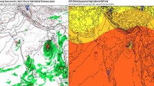

The India Meteorological Department (IMD) on Friday issued heavy rainfall warning for four districts of Odisha on May 10 during the approach of the possible cyclonic system from the Bay of Bengal towards the north Andhra and Odisha coasts.

The landfall process has started and the process will take nearly 3-4 hrs, as Yaas is not a fast-moving cyclone. The motion will reduce to half when it touches Odisha landmass.

Just a few hours before the landfall of 'Yass' a miniature tornado created havoc in parts of Hooghly and North 24 Parganas on Tuesday evening. Though the weather department said that these kinds of tornadoes are common ahead of a major cyclone but also admitted that it is very unlikely at a place which is nearly 210 kilometres away from the landfall.

Currently, Cyclone Yaas is having marginally unfavorable vertical wind shear. However, just prior to landfall, wind shear will turn supportive and Yaas to attain peak intensity

More than 75,000 volunteers have been put on standby in Bangladesh to deal with the possible effects of Cyclone 'Yaas' which is now developing over the east-central Bay of Bengal, officials said.

Prime Minister Narendra Modi on Sunday directed all senior officers to work in close co-ordination with states to ensure the safe evacuation of people from high-risk areas in the wake of cyclone Yaas and instructed all concerned departments to ensure timely evacuation of those involved in off-shore activities.

With the low pressure on East central Bay of Bengal set to turn into a cyclonic storm tomorrow, the Odisha government has pulled all efforts in strengthening it's action plan to tackle the probable disaster.

The Low Pressure over East-Central Bay of Bengal has intensified into a well-marked low pressure system, the Regional Meteorological Centre of the IMD informed on Sunday.

"The public health challenges already posed by the Covid-19 pandemic may be compounded due to the direct impact of the cyclone in terms of waterborne, vector-borne and airborne diseases that may arise in the community or in the displaced population in camps and temporary shelter settings."

Ahead of the formation of a low pressure in north Andaman Sea and its neighbouring East Central Bay of Bengal and possible intensification into a cyclone, Odisha government on Friday informed that it has initiated exhaustive disaster management exercise with arrangements at all level while also ruling out the chances of any flood-like situation in the State.

The brewing of a fresh low pressure in North Andaman Sea and its adjoining East-central Bay of Bengal and its likely intensification into a cyclonic storm has trigerred major concerns for crop cultivators amid this pandemic crisis.

Eastern states of Odisha and West Bengal are likely to face the brunt of the upcoming storm next week as the storm is expected to make landfall by May 26

With the extremely severe cyclonic storm Tauktae wreaking havoc on the western coast of India, another cyclonic storm might be brewing in the Bay of Bengal (BoB).

Bhubaneswar: The Odisha government on Wednesday ordered closure of all educational institutions in the state from May 2 in view of the cyclonic storm ‘Fani’, which is likely to hit the coast on May 3 afternoon. “All educational establishments should declare holidays from May 2 till further orders. All the examinations should be rescheduled,” said the […]

Bhubaneswar: Seemingly a big relief for Odisha. The ‘Bulbul’ will not come for nest-searching in the State. Almost all lead Met agencies world over has made the forecast of relief for the State. There is now apparently unanimity in the Met community that the tropical cyclone Bulbul will not make land fall in Odisha. And […]

Copyright © 2024 - Odisha Television Limited All Rights Reserved.