Twitter
 Telegram
 Google News
Thunderstorm with lightning alert
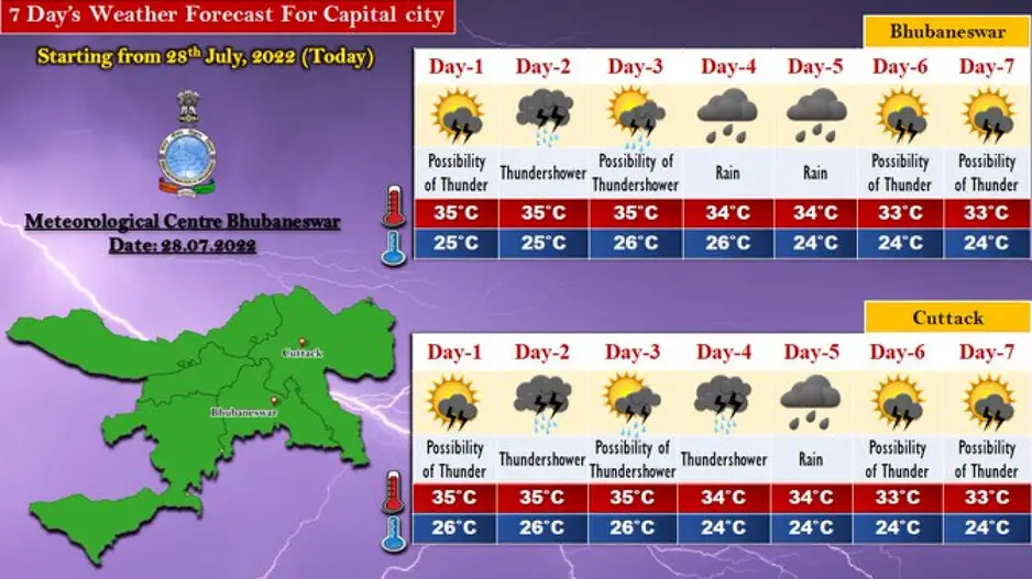
Southwest monsoon has subdued over Odisha with considerable drop in the rainfall activities in the past couple of days.
The India Meteorological Department (IMD) on Thursday said the monsoon trough at mean sea level now passes through Ganganagar, Narnaul, Aligarh, Kanpur, Daltonganj, Berhampore and thence eastwards to Imphal across Bangladesh and Silchar.
Even though there is no major forecast for heavy rainfall activities in Odisha, several districts might experience light to moderate rainfall or thunderstorm activities in the next few days, said the weather bureau.
Weather Forecast and Warnings: Day-1 (valid up to 0830 hrs IST of 29.07.2022)
Yellow Warning( Be updated): Thunderstorm with lightning very likely to occur at one or two places over the districts of Sundargarh, Jharsuguda, Bargarh, Sambalpur, Deogarh, Angul, Dhenkanal, Keonjhar, Mayurbhanj, Malkangiri, Koraput, Rayagada, Kandhamal, Kalahandi, Bolangir, Boudh, Sonepur, Nayagarh.
Day-2 (valid from 0830 hrs IST of 29.07.2022 up to 0830 hrs IST of 30.07.2022)
Yellow Warning( Be updated):Thunderstorm with lightning very likely to occur at one or two places over the districts of Malkangiri, Koraput, Nawarangpur, Rayagada, Gajapati, Ganjam, Nayagarh, Boudh, Angul, Dhenkanal, Sundargarh, Keonjhar, Mayurbhanj, Jajpur, Balasore, Bhadrak, Deogarh.
Day-3 (valid from 0830 hrs IST of 30.07.2022 up to 0830 hrs IST of 31.07.2022)
Yellow Warning( Be updated): Thunderstorm with lightning very likely to occur at one or two places over the districts of Malkangiri, Koraput, Nabarangpur, Kalahandi, Kandhamal, Boudh, Angul, Sundargarh, Deogarh, Keonjhar.
Day-4 (valid from 0830 hrs IST of 31.07.2022 up to 0830 hrs IST of 01.08.2022)
Light to Moderate Rain or Thundershower very likely to occur at a few places over the districts of Odisha.