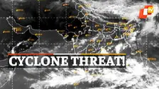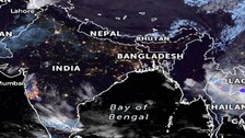

IMD DG Mrutyunjay Mohapatra on Tuesday said that the system is likely to move west-northwest wards and concentrate into a depression by October 22 over central Bay of Bengal.

With a cyclonic circulation having already formed over the south Andaman Sea and neighbourhood, people in Odisha, particularly those living in coastal areas are in fear and apprehension.

India Meteorological Department’s (IMD) Regional Centre in Bhubaneswar on Monday informed that no forecast has been received for cyclone in the next 15 days.

Cyclones & Odisha: List Of Cyclones That Hit The State

As per IMD, a cyclonic circulation is likely to form over South Andaman Sea and neighbourhood around May 4. Under its influence, a low pressure area is likely to form over the same region during the next 24 hours.

The Odisha government on Friday stepped up measures in view of the looming cyclone threat.

As per IMD, the current Low-Pressure area now lies as a well-marked low pressure over southeast Bay of Bengal and adjoining Andaman Sea.

The Low Pressure Area (LPA) that formed over central parts of Andaman Sea and neighbourhood now lies as a Well Marked Low over southeast Bay of Bengal adjoining Andaman Sea.

Apart from the coastal belt, the State government has also asked the Collectors of Mayurbhanj and Nayagarh districts to step up preparedness and remain alert owing to the emergency situation arising out of the possible cyclonic storm.

Models predict very heavy rainfall (8-16mm/hr) in the districts of Jagatsinghpur, Jajpur, Keonjhar, Bhadrak, Angul, Dhenkanal etc. Rest of the districts will be recording rainfall in the range of 2-4mm/hr

Bhubaneswar/ New Delhi: Amidst reports of a possible cyclonic storm creating panic among people, the Indian Meteorological Department (IMD) on Monday announced that there is no cyclone threat to Odisha. Mrutyunjay Mohapatra, head of Cyclone Warning Division of IMD in an exclusive interview to OTV, said that the depression has turned into a deep depression […]

Bhubaneswar: With the forecast by the India Meteorological Department (IMD) that a possible cyclonic storm over Bay of Bengal is most likely to have landfall on Odisha coast, the state government has geared up its machinery to tackle the calamity. Talking to OTV today, Dr Mrutyunjay Mohapatra, head, Cyclone Warning, IMD, said the deep depression […]

The Cyclonic Storm 'Tauktae' is intensifying into a Severe Cyclonic Storm and is very likely to further intensify into a Very Severe Cyclonic Storm Saturday night. It is very likely to move north-northwestwards and cross Gujarat coast between Porbandar and Naliya in the afternoon or evening of May 18. Under its influence, heavy to very heavy falls will be witnessed at a few places and extremely heavy falls at isolated places over Kerala and over Coastal and adjoining Ghat districts of Karnataka on May 15 and heavy to very heavy falls at isolated places over the same area tomorrow. Heavy to very heavy falls also likely at a few places over south Konkan & Goa and heavy to very heavy falls at isolated places over north Konkan on the 15th.

Kolkata: The Indian Navy has kept on standby its aircraft and three ships for immediate deployment in the eventuality of any damage by severe cyclonic storm Bulbul, which is expected to make landfall by Saturday midnight, a Defence Ministry spokesperson said. The spokesperson said the Eastern Naval Command (ENC) was closely monitoring the movement of […]

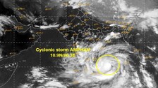
Bhubaneswar: With the depression in Bay of Bengal intensifying into cyclonic storm Amphan, Odisha government is bracing up to face any situation as the storm is expected to re-curve and move towards north Odisha coast. Cabinet Secretary Rajiv Gauba reviewed Odisha’s preparedness for the impending cyclone amidst ongoing COVID-19 management activities. While briefing the Cabinet […]

Copyright © 2024 - Odisha Television Limited All Rights Reserved.