Twitter
 Telegram
 Google News
Low Pressure Over BoB Next Week; Check IMD’s Latest Forecast
A low pressure is likely to form over southeast Bay of Bengal next week, said India Meteorological Department (IMD) on Sunday.
IMD’s Regional Centre in Bhubaneswar said, “ An upper air cyclonic circulation likely to form over South Andaman Sea and neighbourhood on April 6. Under its influence, a Low Pressure area is likely to form over Southeast Bay of Bengal during subsequent 24 hours.”
Under the influence of strong south-westerly winds from Bay of Bengal to north-eastern States at lower tropospheric levels, heavy rainfall is likely over Arunachal Pradesh, Assam-Meghalaya and Nagaland, Manipur, Mizoram and Tripura during next 5 days.
Weather Forecast
Day-2 (valid from 0830 hrs IST of 03.04.2022 up to 0830 hrs IST of 04.04.2022)
Light to moderate rain/ thundershower is very likely to occur at one or two places over the districts of Keonjhar, Mayurbhanj, Balasore, Bhadrak, Kendrapara Rayagada, Gajapati, Koraput and Malkangiri.
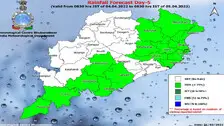
Day-3 (valid from 0830 hrs IST of 04.04.2022 up to 0830 hrs IST of 05.04.2022)
Light to moderate rain/ thundershower is very likely to occur at one or two places over the districts of North Coastal Odisha, Malkangiri, Koraput, Gajapati, Ganjam, Rayagada, Kandhamal, Mayurbhanj and Keonjhar.