Twitter
 Telegram
 Google News
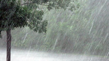
IMD's predicts thunderstorm on September 11 and 12
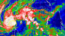
The cyclonic circulation over central parts of interior Odisha and adjoining Chhattisgarh now lies over southeast Madhya Pradesh and neighbourhood and it extends up to 7.6 km above mean sea level tilting southwards with height.
The India Meteorological Department (IMD) on Friday informed that the monsoon trough at mean sea level now passes through Jaisalmer, Kota, Raisen, Pendra Road, Jamshedpur, Digha and thence east-south-eastwards to Northeast Bay of Bengal.
As per IMD, there will be a considerable drop in rainfall activities in several parts of Odisha in the next two days. However, an alert has been issued for thunderstorm and heavy rainfall activities for September 11 and 12.
Day 1 (Valid upto 0830 hrs IST of 09.09.2023)
Yellow Warning: Heavy rainfall very likely to occur at one or two places over the districts of Sundargarh, Bargarh, Jharsuguda, Keonjhar, Mayurbhanj, Balasore, Bhadrak, Jajpur, Angul, Dhenkanal, Cuttack, Sambalpur, Deogarh.
Day 2 and Day 3 up to September 10 (No Warning)
Day 4 (Valid from 0830 hrs IST of 11.09.2023 to 0830 hrs IST of 12.09.2023)
Yellow Warning: Thunderstorm with lightning very likely to occur at one or two places over the districts of Balasore, Bhadrak, Jajpur, Kendrapara, Cuttack, Jagatsinghpur, Puri, Khurda, Nayagarh, Ganjam, Gajapati,Angul, Dhenkanal, Mayurbhanj, Keonjhar, Sundargarh, Koraput, Malkangiri, Rayagada, Kandhamal.
Day 5 (Valid from 0830 hrs IST of 12.09.2023 to 0830 hrs IST of 13.09.2023)
Yellow Warning: Thunderstorm with lightning very likely to occur at one or two places over the districts of Balasore, Bhadrak, Jajpur, Kendrapara, Cuttack, Jagatsinghpur, Puri, Khurda, Nayagarh, Ganjam, Gajapati, Keonjhar, Mayurbhanj, Sundargarh, Jharsuguda, Angul, Dhenkanal.
Heavy rainfall very likely to occur at one or two places over the districts of Ganjam, Kandhamal, Angul, Cuttack, Nayagarh, Kalahandi, Boudh, Gajapati, Rayagada, Dhenkanal, Koraput, Nabarangpur.