Recommended Stories
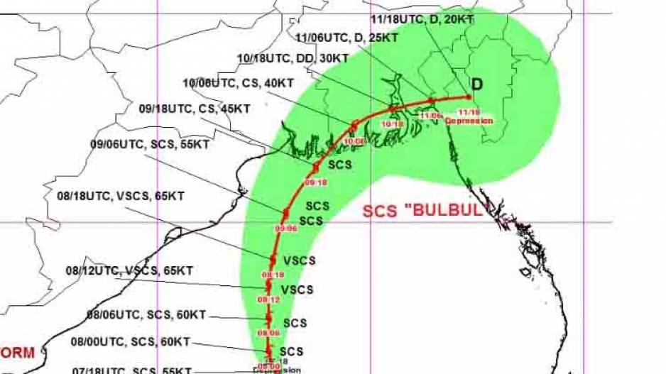
Bhubaneswar: Even though India Meteorological Department has ruled out likelihood of severe cyclonic storm Bulbul hitting Odisha coast, the State government has issued orange and yellow warning in view of possible impact of the cyclone while it moves along the coast to make landfall probably between Sagar Islands (West Bengal) and Khepupara (Bangladesh) during the early hours of November 10.
The Meteorological Centre in Bhubaneswar has issued yellow warning for four districts Puri, Jagatsinghpur, Kendrapara and Bhadrak. Light to moderate rain or thundershower is very likely to occur over these north coastal districts and at a few places over the rest districts of coastal Odisha and at isolated places over the districts of interior Odisha.
Orange warning has been issued for districts of Balasore, Bhadrak, Kendrapara and Jagatsinghpur on November 9. Heavy to very heavy rainfall is very likely to occur at isolated places over these districts. Rainfall activity is also likely to be witnessed at many places over districts of south coastal Odisha and at a few places over the districts of interior Odisha.
The Met Centre has forecast that the intensity of rainfall will decrease after November 10 even though light to moderate rain is very likely to occur at many places over the districts of north coastal Odisha, at a few places over districts of south coastal Odisha, Mayurbhanj, Keonjhar and isolated places over rest district of Odisha.
Under the impact of the cyclonic storm, strong wind speed reaching 35– 45 kmph gusting to 55 kmph is likely to commence along the coasts of, Jagatsinghpur, Balasore and Bhadrak districts today and very likely to increase becoming squally wind speed reaching 45-55 kmph gusting to 65 kmph by afternoon. Gale wind speed reaching 70-80 kmph gusting to 90 kmph likely from the afternoon of 9th November. Puri, Ganjam and Jajpur districts are likely to experience squally wind speed reaching 40-50 kmph gusting to 60 kmph on 8th & 9th of November. It is likely to decrease from November 10 onwards.
Sea condition will be rough to very rough along and off Odisha coast from November 8 onwards becoming very high on 9th and 10th November.
While fishing operations have been completely suspended, the Met Centre has warned people to stay indoors in the districts which are more likely to face the impact of the cyclone.
Local cautionary signal no. THREE (LC –III) has been hoisted at all ports of the State.
As per IMD sources, severe cyclonic storm Bulbul which turned into a very severe cyclonic storm at 5.30 AM on November 8 lay centred 390 km south-southeast of Paradip 530 km south-southwest of Sagar Islands (West Bengal) and 630 km south-southwest of Khepupara (Bangladesh).
Moving at a speed of 10 kmph, it is very likely to intensify further till early morning of 9th November and very likely to move initially north-northwestwards for next 12 hours and then nearly northwards till 9th November morning.
It is likely to make landfall somewhere across Sunderban delta in wee hours of November 10 as a Severe Cyclonic Storm with wind speed of 110-120 kmph gusting up to 135 kmph.


