/odishatv/media/agency_attachments/2025/07/18/2025-07-18t114635091z-640x480-otv-eng-sukant-rout-1-2025-07-18-17-16-35.png)
/odishatv/media/member_avatars/2025/09/26/2025-09-26t140800004z-flagwe-2025-09-26-19-38-01.jpg )

/odishatv/media/post_attachments/uploadimage/library/16_9/16_9_0/recent_photo_1734882465.JPG)
Odisha braces for Kalbaisakhi rains, relief from intense heat expected
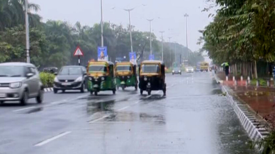
Odisha is all set to experience a much-needed respite from the soaring temperatures as the Kalbaisakhi rains are all set to commence today. The regional meteorological department anticipates a significant change in weather, promising cooler conditions.
With the Nor’wester rains likely from today, Odisha is set to experience a welcome respite from the intense heat. Starting today, temperatures are expected to fall, with possible thunderstorms adding to the change. The Indian Meteorological Department (IMD) has indicated that these conditions may continue until 22nd April.
Expected Cooler Temperatures:
Regions across the state could experience thunderstorms accompanied by rain, lightning, and gusty winds as moisture-laden air moves into central Odisha. The arrival of moist air will introduce significant humidity, potentially leading to rainfall accompanied by lightning and thunder. Recent days have seen a slight decrease in temperature, and the rains are expected to contribute to a further dip, potentially lasting until 22 April.
Temperature Relief Noted:
Yesterday, temperatures saw a noticeable dip compared to previous days, with all cities recording below 40°C. Jharsuguda noted the highest temperature at 39.8°C. Residents across Odisha are advised to stay prepared for the shift in weather and take necessary precautions during thunderstorms.
Weather Forecast:
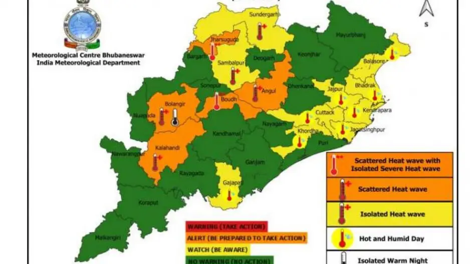
Day 1 (Valid upto 0830 hrs IST of 19.03.2025)
Yellow Warning: Heat wave condition is very likely to prevail at one or two places over the districts of Bargarh, Sambalpur, Boudh, Sonepur.
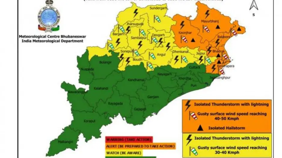
Day 2-3 (Valid from 0830 hrs IST of 20.03.2025 to 0830 hrs IST of 21.03.2025)
Orange Warning: Thunderstorm with lightning and hail with gusty surface wind speed reaching 40-50 kmph is very likely to occur at one or two places over the districts of Balasore, Bhadrak, Keonjhar, Mayurbhanj, Kendrapada.
Yellow Warning: Thunderstorm with lightning with gusty surface wind speed reaching 30-40 kmph is very likely to occur at one or two places over the districts of Sundargarh, Jajpur, Dhenkanal, Jharsuguda, Sambalpur, Bargarh, Sonepur, Boudh, Angul, Deogarh.
Day 4 (Valid from 0830 hrs IST of 21.03.2025 to 0830 hrs IST of 22.03.2025)
Orange Warning: Thunderstorm with lightning and hail with gusty surface wind speed reaching 50-60 kmph is very likely to occur at one or two places over the districts of Mayurbhanj, Keonjhar, Sundargarh, Jharsuguda, Sambalpur, Angul, Dhenkanal.
Yellow Warning: Thunderstorm with lightning with gusty surface wind speed reaching 40-50 kmph very likely to occur at one or two places over the districts of Balasore, Bhadrak, Jajpur, Kendrapara, Cuttack, Jagatsinghpur, Bargarh, Deogarh.
Day 5 (Valid from 0830 hrs IST of 22.03.2025 to 0830 hrs IST of 23.03.2025)
Orange Warning: Thunderstorm with lightning and hail with gusty surface wind speed reaching 50-60 kmph is very likely to occur at one or two places over the districts of Mayurbhanj, Keonjhar, Sundargarh.
Yellow Warning: Thunderstorm with lightning with gusty surface wind speed reaching 30-40 kmph is very likely to occur at one or two places over the districts of Balasore, Bhadrak, Jajpur, Kendrapara, Cuttack, Jagatsinghpur, Jharsuguda, Bargarh, Sambalpur, Deogarh, Angul, Dhenkanal.
Cyclonic circulation to trigger thunderstorm over Assam, Nagaland; hailstorm likely over east central India
Heat wave and thunderstorm to lash Odisha districts; IMD issues orange and yellow warning
Heat wave in Odisha! Boudh hottest place in country for third consecutive day

Thunderstorm to bring temperature down: IMD issues orange warning for Odisha districts
/odishatv/media/media_files/2025/09/22/advertise-with-us-2025-09-22-12-54-26.jpeg)
