/odishatv/media/agency_attachments/2025/07/18/2025-07-18t114635091z-640x480-otv-eng-sukant-rout-1-2025-07-18-17-16-35.png)
/odishatv/media/member_avatars/2025/09/26/2025-09-26t140800004z-flagwe-2025-09-26-19-38-01.jpg )

/odishatv/media/post_attachments/uploadimage/library/16_9/16_9_0/recent_photo_1729502288.webp)
Cyclone Dana: When and where will it make landfall, Odisha or WB? All details here
While Odisha anticipated the withdrawal of Southwest Monsoon due to favourable conditions, the India Meteorological Department (IMD) on Tuesday i.e. October 15 gave a shocker with a low-pressure warning.
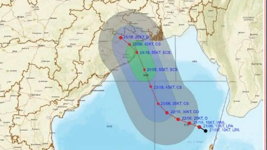
Initially taken lightly for being just another low pressure, it turned out to be the season’s first cyclone. It is slowly intensifying into a depression and will most likely turn into a cyclonic storm by 23rd October. Thereafter, it is very likely to move northwestwards and reach the northwest Bay of Bengal off the Odisha-West Bengal coasts by the 24th of October morning, triggering heavy rainfall in the state accompanied by gusty surface wind up to the speed of 40-50kmph.
Cyclonic Storm Confirmation
Cyclone Dana: Emergency Helpline Numbers
At first, the IMD on Thursday i.e. on October 17 confirmed the formation of a cyclonic circulation over the North Andaman Sea. “A fresh upper air cyclonic circulation is very likely to form over North Andaman Sea around 20 October. Under its influence, a low-pressure area is likely to form over the Central Bay of Bengal around October 22, thereafter, it is likely to move northwestwards and intensify further,” the IMD’s press release then stated.
IMD DG Statement
In an exclusive interview with OTV, IMD DG Mrutyunjay Mohapatra shared the cyclonic circulation will form on October 20 over the Andaman sea and will move west and north-west ward and intensify into a low pressure area over the central Bay of Bengal around October 22. Later, it will move towards north-west direction. It is likely to intensify into a depression around October 24, he said.
“Under its influence, Odisha is likely to experience rainfall activities from October 23 to 25. Odisha will experience maximum rainfall on October 24,” Mohapatra added.
Cyclone Dana Impact
Under the impact of the cyclone, several parts of Odisha are likely to experience heavy to very heavy rainfall from October 23. The intensity of rainfall will be more on October 24 and 25. IMD’s Regional Centre Director Manorama Mohanty on Monday said several parts of Odisha are likely to experience heavy to extremely heavy rainfall.
As per IMD, October 24 and 25 are crucial for Odisha as the low pressure that formed this morning is all set to intensify into depression and subsequently into a cyclonic storm on October 23.
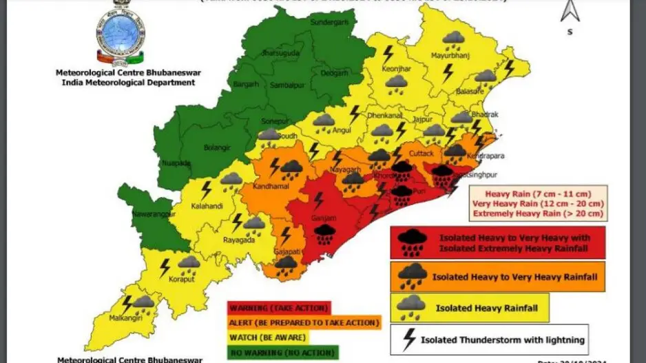
Yellow and Red Warning for Odisha Dictricts
Yellow Warning has been issues for districts of Balasore, Bhadrak, Jaipur, Kendrapara, Cuttack, Jagatsinghpur, Puri, Khordha, Ganjam and Gajpati on October 23. Similarly, Red Warning has been issued for Puri, Khordha, Ganjam and Jagatsinghpur for October 24 and 25.
Odisha Govt Buckles Up
Odisha government is prepared to tackle cyclone and there is no need to panic, informed Revenue Minister Suresh Pujari. The minister informed that the Chief Secretary, SRC and other officials are closely reviewing things and preparations are being made for 30 districts where ODRAF teams will be deployed.
Meanwhile, the Odisha government has cancelled leaves of staff. All officials have been directed to remain at their respective places and perform their duties. District Collectors have the power to take call on holidays for schools considering the situation.
Cyclone Dana Expected Landfall
As per early estimation, the cyclone is very likely to cross north Odisha and West Bengal coasts between Puri and Sagar Island.
“Continuing to move northwestwards, it is very likely to cross north Odisha and West Bengal coasts between Puri and Sagar Island during the night of October 24 and early morning of October 25 as a severe cyclonic storm with a wind speed of 100-110 kmph gusting 120 kmph,” IMD informed today.
Cyclone Dana Naming
The cyclone has been named ‘Dana’ and has raised serious concerns about the destruction it may bring in the coming days. As per reports, the name Dana was contributed by Saudi Arabia, one of the 14 countries participating in the WMO’s tropical cyclone naming system for the North Indian Ocean. As per reports, the name ‘Dana’ is derived from Arabic and means ‘generosity’ or ‘bounty’.
Cyclone Dana: IMD issues Red Warning for heavy to very heavy rainfall in several Odisha dists
Cyclone Dana: Low pressure area formed over eastcentral BoB, intensifying into depression
Cyclone Dana to cross north Odisha and WB coasts between Puri and Sagar Island on Oct 24: IMD
Cyclone threat to Odisha: As cyclonic storm Dana approaches, know a few Do's and Don'ts

/odishatv/media/media_files/2025/09/22/advertise-with-us-2025-09-22-12-54-26.jpeg)
