
India Meteorological Department (IMD) on Friday said light to moderate rainfall with isolated heavy rainfall and thunderstorm very likely over Tamil Nadu, Puducherry and Karaikal during October 28 and November 1.

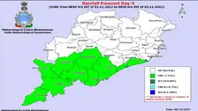
IMD's Regional Centre in Bhubaneswar informed that warning has been issued for heavy rainfall activities in south coastal parts of the state.

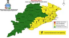
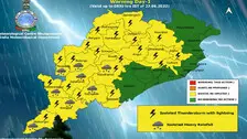
As per IMD, several parts of the state are likely to experience heavy rainfall activities for the next couple of days. A yellow warning for thunderstorm and heavy rainfall has been issued for various districts till October 11.

A cyclonic circulation lies over Westcentral Bay of Bengal and adjoining Andhra Pradesh coast at 1.5 km above mean sea level, the India Meteorological Department (IMD) said on Saturday.

An upper air cyclonic circulation is likely to form over North Bay of Bengal around September 18, said India Meteorological Department (IMD) on Thursday.

As per the IMD, the associated cyclonic circulation also extends up to mid-tropospheric levels.

As per IMD's Regional Centre in Bhubaneswar, as many as 22 places in Odisha recorded day temperature of 35 degrees Celsius or above on Friday

Regional centre of the IMD in Bhubaneswar issued orange and yellow alerts for several Odisha districts for the next 24 hours. As per the IMD weather bulletin, light to moderate rain or thundershower is very likely to occur at most places of Odisha from 8:30 am on Wednesday till 8:30 am on Thursday. IMD has issued an orange warning for the districts of Sundargarh, Jharsuguda, Sambalpur and Deogarh.

As per the predictions of the Regional centre of the India Meteorological Department in Bhubaneswar, the low pressure area over coastal Odisha and its neighbourhood, now lies over Northwest Bay of Bengal off North Odisha-West Bengal coasts.

Yesterday's Low Pressure Area over coastal Odisha & neighbourhood now lies over Northwest Bay of Bengal off north Odisha-West Bengal Coasts and the associated cyclonic circulation extends upto 7.6 km above mean sea level.

Meanwhile, the MeT office has issued 'yellow warning' for 24 district for today while orange warning has been issued for eight districts for the next 24 hours in view of the rainfall activities.

As per the Met Centre, the eastwest trough now runs from above cyclonic circulation over northwest Rajasthan and neighbourhood to Westcentral Bay of Bengal across East Rajasthan, Madhya Pradesh, Chhattisgarh and south Odisha.

As per IMD, the conditions are favorable for further advancement of monsoon into some more parts of Madhya Pradesh, remaining parts of Vidarbha, Andhra Pradesh and Westcentral & northwest Bay of Bengal, more parts of Chhattisgarh and Odisha, Gangetic West Bengal, Jharkhand and parts of Bihar during the next three days.

As per IMD, the conditions are favourable for further advance of monsoon into some parts of north Arabian sea, remaining parts of Konkan, some parts of Gujarat state, most parts of Madhya Maharashtra, entire Karnataka and Tamil Nadu, some parts of Telangana, Andhra Pradesh, Westcentral & northwest Bay of Bengal during the next 24 hours.

The IMD has predicted that an intense spell of rainfall is likely to continue over Northeast India and Sub-Himalayan West Bengal and Sikkim during the next five days.

Copyright © 2024 - Odisha Television Limited All Rights Reserved.