The Ministry of Jal Shakti has said that during 2021, under the Aquifer Mapping programme, an area of 18.4 lakh sq km out of the total 25 lakh sq km area identified for mapping in the country has been covered.
Also, Aquifer Maps and Management Plans for 3.7 lakh sq km have been prepared covering various parts of the country for the duration between January 1 to November 30, 2021, a release from the Jal Shakti Ministry said.
All these exercises have been carried out as part of the National Aquifer Mapping and Management Programme (NAQUIM) wherein studies for aquifer mapping and management plan formulation have been taken up by the Central Ground Water Board (CGWB) under the scheme Ground Water Management & Regulation.
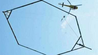
Under the 'High Resolution Aquifer Mapping and Management In Arid Areas Of India' head, the CGWB, also a body under the Ministry of Jal Shakti, has initiated a high-resolution mapping of aquifers using modern Heli-borne geophysical survey in parts of the arid areas spread over the states of Rajasthan, Gujarat, and Haryana.
"The study has been taken up in collaboration with the Ministry of Science and Technology. Under phase- I of the project, the work has been initiated in nearly 1 lakh sq km. Heli-borne survey under this project was inaugurated by Minister for Jal Shakti, Gajendra Singh Shekhawat, and Minister of State (Independent Charge) of Science & Technology, Dr Jitendra Singh on October 5 at Jodhpur, Rajasthan," the release said.
Realizing the need for availability of reliable and up-to-date water data for efficient management of water resources of the country, the Government has recently established National Water Informatics Centre as a repository of nation-wide water resources data and as a reliable system for water resources data storage, collation, management, and dissemination. Data on water resources and allied themes like rainfall, river water levels and discharge, ground water levels, reservoir levels, water quality, soil moisture, etc. are disseminated through a GIS enabled public platform "india.wris.gov.in" to all stakeholders and general public.

 TV
TV


